该公园位于德国西北部的北部低地与西北部丘陵区之间的过渡带上,距北部海岸约100公里,距荷兰边境35公里,为一联邦共和国跨境公园,占地面积1220平方公里,其中901平方公里的面积位于奥斯纳布吕克地区,其余319平方公里位于名登-吕伯克等地。
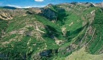
从地质角度,该公园可分为两个区,北部称作“Ankum-Bippener冰山”,是一宽40公里、高出海平面140米的终碛的西部,该冰山的最高峰高140米,比周围低地高出115米。南部是平均山地地貌,底土由块状岩石组成,有些地方被冰期沉积物所覆盖。
该终碛是在萨勒冰期开始形成的,专家们认为它是德国西北部最重要、发育最强烈的终碛之一。在几次冰期演进期间,较老的底土物质(主要是第三纪粘土物质)推挤到一起,并堆积下砂砾等冰水沉积物。
在山脊上,几处单个终碛表面依稀可见。该终碛上可能叠加了萨勒冰期晚期冰碛物。位于该冰碛的东部与西部之间的原先的舌状冰川盆地,如今称作“Artland”。这些主要冰川要素周围主要被地表冰碛所覆盖,只发育有几处冰水沉积物。
按照地质学的观点,公园南部属于德国平均山地地貌的一部分。作为楔形山体隆起,这一杂岩体将南部的“明斯特兰盆地”与西北部低地隔离开。地质学家把这一杂岩体称为西北falian-lippian隆起,从而对其他平坦景观内部的抬升构造做出了解释。
按照一般观点,这一山体隆起为一背斜,可划分为几个较小的亚构造,如逆掩断层、地垒、次级背斜和隆起等。目前我们可从这一背斜构造中发现剥蚀特别是冰期影响在地貌形成中的作用。
此外,公园南部还有一处最著名的地质遗迹——“Barkhausen恐龙足迹”。在该遗址南部,可以见到中-早侏罗世岩石,主要是松软的叶状粘土岩。
有些地方可以发现一种特殊的黑色叶状粘土岩,称作“Vehrte黑垩”。它是在某些深成作用期间发生煤化的。
介于维恩山和条顿堡林山两条构成边界的山脉之间的地貌称作“Osnabrucker Hugelland”。该区以三叠纪岩石露头为特征,最常见的是晚三叠世粘土岩和中三叠世坚硬石灰岩,但有些地方也出现有明显呈红色的早三叠世叶状和沙质岩石。其出露地层的边缘往往穿切冰期沉积物(主要是冰碛物或黄土),形成典型的当地单面山景观。在3个地点,出现与地垒断层或桌状断层相关的古生代晚二叠世和石炭纪岩石隆起。碳酸盐岩(特别是白云岩)是二叠纪的特征,石炭纪岩石则由砂岩、砾岩、叶状粘土岩甚至无烟煤组成。
TERRA.vita Geopark is located in North-Western Germany in the transitional zone between the northern German lowlands and the north-western hill country, at a distance of about 100 kilometers from the north sea coast and some 35 kilometers east of the Dutch border. With an area of 1.220 square kilometers, the Naturpark is one of the cross-border Parks of the Federal Republic of Germany. 901 square kilometers, are located in Lower Saxony, in the district of Osnabrueck. The rest of the territory, 319 square kilometers, are located in North-Rhine Westfalia in the districts of Minden-Luebbecke, Herford, Gueterslohand the city of Bielefeld. 70% of the Natural Park are covered with forests, the other 30% are mostly used for agriculture.
Geologically, the Natural Park can be subdivided in two regions: The northern part, the so-called "Aenkum-Bippener Berge" or "Aenkumer Hoehe", represents the western part of an altogether 40 km broad "End-moraine" with heights above sea level of up to 140 m. This landscape was formed during the ice age and its elevation is higher than the surrounding northern German lowlands. The southern part of the park is classed as belonging to an average-mountain landscape. Its subsoil consists of massive rock, that is covered by ice age sediments in some places. The highest point of the average-mountain landscape is the “Doerenberg” at 331m above sea level.
The "Aenkum Bippener Berge":
This "Endmoraine" was created during the Drenthe-stage of the Saale ice age. Experts classify it as one of the most significant and best developed "End-moraines" of North-Western Germany. During several ice advancements older subsoil material, mainly clay sediments of the Tertiary age, were pushed together at the same time as glacio-fluviatile material like sand and gravel was accumulated.
In the interior of the ridge, several single ice-marginal grounds are visible. The "End-moraine" was most likely superimposed by later ice advancements of the Saale-ice age. The former tongue-like basin of the glacier between the eastern and western part of the moraine is called "Artland" today. The surroundings of these main glacial elements are mainly covered with ground-moraines, just a few glacial outwashes are developed.
Average mountains:
From a geological-geographical viewpoint, the southern part of the Nature Park belongs to the German average-mountain landscape. As a wedge-shaped mountain-ridge this complex separates the "Muensterland basin" in the south, from the north-western lowlands. Geologists call this complex the North-Westfalian-Lippian ridge, caused by tectonic folding and surrounded by a commonly horizontally bedded, flat landscape.
This mountain-ridge represents a geological anticline, characterized by several smaller sub-structures like over-thrusts, faults, horsts, inferior anticlines and uplifts. Outside the anticline, erosional processes and the influence of glaciation during the ice ages in particular created the morphology of today.
The southern area of the Nature Park can be further divided into three different geological-geomorphological entities. The northern edge is formed by the "Wiehengebirge" and the "Wesergebirge", it consists of Jurassic rocks. The crest of the central mountain chain is made up of Upper Jurassic sand- and limestones. One of the most famous Geosite (or "Geotop"), the "Dinosaur Footprints of Barkhausen" is located in these layers. In the southernmost part of the Park, outcrops of Middle and Lower Jurassic rocks can be found that consist mainly out of soft shaly claystones, often interspersed with clay-iron concretions.
Contact:
Naturpark TERRA.vita:
Am SchBerberg 1
49082 Osnabrück
Telefon: 05 41 / 501 42 17
Telefax: 05 41 / 501 44 24
eMail: info@naturpark-terravita.de


